YOUNG AMERICA at Bannerman's Island

YOUNG AMERICA at Bannerman's Island

Tuesday, August 27, 2013

St. Louis to the Quad Cities August 15-22, 2013


Heading north.  We were very impressed with the owners of the Two Rivers Marina---they were expecting a big crowd Labor Day weekend, and the working guys opened each power pedestal and vacuumed out the spiderwebs; then scrubbed the pylon with a fingernail brush!  Holy cleanliness, Batman (Ben Affleck, of course)!


The marina owner, has  all the toys: a small tug, a dredge, a party boat he built in his machine shop, and a restaurant in Louisiana---MO, that is. I wonder if he also has a headache or two from time to time from owning a marina and a resturant.  Bless him.

Sing ho for the locks!  They create lakes and slow the current we faced in the goofy 200.  Two locks and a railroad swing bridge (which must swing open if it is too low for us to pass under) seem to be the order of most days.  We’ve been lucky with locks---most of the time we drive right in.   There are no floating bollards, and the lift is usually less than 15’, so with lines fore and aft we ride up easily.  Of course we learned this by attempting to use one central line as we do with a floating bollard.  Doesn’t work as the wind in the Midwest is as I remember it from my childhood in SD. Strong and unpredictable.  Two lines per lock from now on.

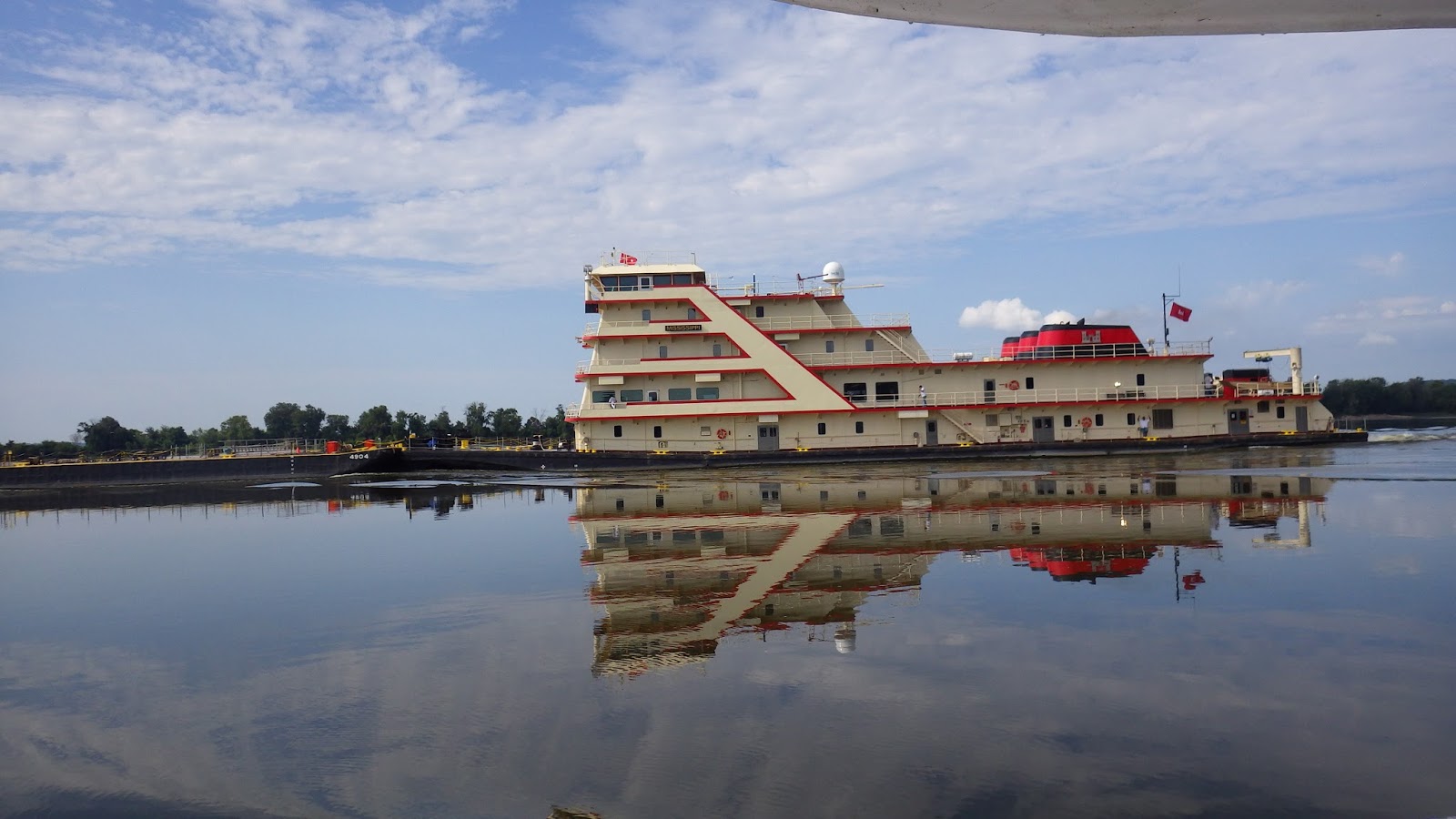
One of the interesting boats we passed was the huge Army Corps of Engineers towboat, the MISSISSIPPI.  Here is what Wikipedia says about it:

The M/V Mississippi is a working towboat for the USACE Memphis District. Ninety percent of the time it is moving barges, equipment and supplies in support of mat sinking operations. It also serves as an inspection boat for the Mississippi River Commission (MRC) during a high- and low-water inspection trip each year. Commissioners hold meetings at river towns in the boat's hearing room, which can seat 115 people. Its dining room has a capacity of 85 people. The boat has 22 staterooms and can handle 150 passengers. The Corps also uses it as a "giant floating ambassador".[1]

Whew.  Emphasis on the 'giant' part.

A fun stop was the Keokuk, IA Yacht Club.  Lots going on there.  We slid easily into their fuel dock, where 2 fellows helped with lines.  One said  of the other: “Be sure he’s careful with his hands---he’s a surgeon”.  To which the surgeon replied, “I’d rather take out an appendix than drive that thing!”

The NINA and the PINTA were docked at Keokuk. They’re Brazil built exact replicas of the boats ol' Chris crossed the Atlantic with, way back when.   They also had an exciting night on the River---rafted together overnight while tied to an island when they couldn’t reach a safe harbor.  The Mississippi is unforgiving. 


Vic, the first mate on the Nina, left a Sacramento, CA computer company (and much bigger bucks) to sail on the Nina.  He’s never looked back---has enjoyed seeing the Great Loop 4 times, Panama Canal, Alaska and the San Juans, and many South American countries.  Their next stop is Green Turtle Bay in KY.  Google will get you more info.

The River was still as a millpond when we left in the morning.  The day was filled with tow boats, locks, and railroad bridges with and without trains.  Two of the RR swing bridges swing onto lock walls.  That sight was a first for us.


Our marina choice for one evening didn’t put their docks in the water this year.  Times have been tough.  Second choice had 0.0 feet of water at the entrance.  Not hardly enough, so Fred rocked us back off the bottom with the bow thruster, and we crossed the River to anchor behind an island, near Burlington, IA.


Next morning, we were ready to go at 6:30 am (can you believe it?) but the fog was waaaaaay too thick.  So we relaxed over breakfast on the back deck and enjoyed watching it burn off.

As we approached Lock #17 after lunch, we saw about 8 olive drab fishing boats rafted together in the middle of the river.  
Turns out the huge crowd of boats and people we’d seen a few miles before were at an $8.00 Boat and Breakfast party.  As soon as the lock opened, those 8 plus 9 other little go-fast boats joined us inside, and by the time we left the lock (last, of course) they were all out of sight.  Hooray for gas guzzlers---keep the economy rolling!


At 5:30 pm we graded our way into the Muscatine, IA marina,(0-2’ of water) and tied up in a slip that was wide enough but about 10’ too short for us.   Any port, they say….

Did you know that Muscatine was the Pearl Button Capitol of the world?  We didn’t either.  It was Sunday, so we missed the museum, but we did see the oysterman statue---oysters and
mussels: their shells were harvested and holes punched out to create buttons.  We’re told that discarded shells with perfect circles punched out can be found all along the shore.

Needless to say the industry has waned.  Check your buttons.  Mother of pearl?  I think not.  Plastic?  Probably.

Next day we continued up the River ansd crossed from Muscatine, IA to Moline, IL. 
Big brother Gene (he’s 10 years older than me and recently widowered after 62 years of marriage) took us out to dinner on Monday.  On Tuesday and Wednesday we maxed our time together, drank coffee, shopped, visited the riverside hot dog vendor, just hung out.  Priceless.   Later this month Gene, a Korean War pilot who flew--and survived—100 missions over North Korea, armed only with a camera for photo reconnaissance, will be flown to Washington, DC as part of an Honor Flight.  Veterans, each with a chaperone, will spend the day visiting the war memorials.  A full 747 will leave Moline, IL airport at the crack of dawn, and return the vets in the evening.  Very special!   His comment----“they’ve seen my resume, right?  Do you think they’d let me drive?”  

Our last evening in Moline, after Gene had driven back to his home in Geneseo, IL, boat neighbors Scott and Laurie took us on an auto tour of the Quad Cities--- Rock Island and Moline, IL along with Davenport and Bettendorf, IA.

We saw the John Deere factories and research centers and well, John Deere is all over the Quad Cities. 
There is also much Civil War history there---including a POW camp and Veterans cemetery on the Rock Island Arsenal (where Gene spent a good deal of his career—at the arsenaal, not the cemetery….), and of course, the depot for the Rock Island Line---a mighty good line.


Capped the evening with a great dinner at a Vietnamese restaurant.  And the next morning we were off.
John and Laurie, Linda and Fred


A recount of the trip from the Quad Cities to the Twin Cities will be forthcoming.   In the meantime, be well and remember to breathe!


Friday, August 16, 2013

The goofy 200 miles August 9-13, 2013


Before leaving Green Turtle Bay, we had consulted with experienced River boaters---Captain Gordon at our end and (Hoppies) Fern and Charles Hopkins at the one fuel stop 158 miles upstream. Both agreed that the flood season had passed, and the River was low and slow.  Should be no problem, right?    Go!  Said they both!

So off we went, and, as I wrote in the last episode of the Blog, we happily anchored at the mouth of the Ohio.  On our second day of what was expected to be a four day trip, we reached the Diversion Channel, 50 miles upstream.  Friday morning we blithely set out at dawn. And then came the Rain.  The current against us increased from 2 to 4 miles per hour, and slowed our progress enough that it was clear that we wouldn't be able to reach our expected stop (the Kaskaskia River Lock) before dark, so we were forced to find a safe place to anchor.

Fortunately, we were traveling with Mark and Diana Doyle’s "Managing the Waterway" Guidebook, and in it  we found what they call a ‘varsity anchorage' at mile 90. Not for the faint of heart’, said they.  It was our best—actually, our only-- shot.   A U shaped wing dam (Chevron) which provided a break in the current.
The u shaped rock pile was 4-6 feet above the surface of the water
 And so we anchored.   A second anchor off the stern was needed to keep us from swinging into either the stone wall or the current, so we put that out. Because of the current, it took a lot of line for the stern anchor to grab., and we had a bit of a mishap, as our 200 feet of chain rolled right off the capstan (the part that keeps the links of the chain rolling.)  I hauled on the line (which thankfully did not break) and got the chain back in working mode, and  the stern anchor set. We had to move up until we had only 80' of line out behind us, and Knute was then taut with only 80' of chain  in 32' of water.  Not enough, but it had to do.   We phoned Hoppies to let them know where we were and what we were doing (a float plan), and to our dismay learned that because of big rain on the Missouri (and everywhere, it seemed), the Mississippi had risen 5 feet in its banks at mile 158!  We were 60 miles downstream and could expect that water to roll past us---raising the level of the river right over our little dam.  Goodbye protection, Hello current---and debris. 

There was naught to do but to watch, and so we did.  I stayed up till 2:30, playing solitaire and watching the water rise.  After that, Fred watched as the dam mostly disappeared. 
  What we were really looking for was increased current beside the boat.  If the current began to push us back toward our stern anchor, that anchor would have to be pulled in as the bow anchor (Knute) was let out.  (We tied the end-of-chain-securing line off so the chain cannot go out too far again!)   Otherwise there would be lines near the propellers and all sorts of mayhem possible.  We could see that Allstate guy  everywhere!

And lo, the water did rise, but miraculously, the current remained calm in our little circle.  Outside that, it was streaming!  Sticks and logs would ride the waterfall over the rocks of the Chevron and come to a stop, just lolling about in the water around us.  Unbelievable.


In the daylight (6 am) we pulled in the stern anchor, then released Knute and resumed the slog northward.  At about 3 pm we turned into the Kaskaskia River (yesterday’s intended destination) and gratefully tied up to the lock wall. 
Lock wall, with the stern anchor resting on the swim platform
Although we could only walk on the (newly improved since our last visit in 2009) lock wall itself, not into town or anywhere civilized, we were very grateful to be tied to a solid, floating surface for the night.  The River continued to rise another 3 feet overnight.

Naturally, the going was slower on Sunday.  Rarely did we move over the ground at 4 miles per hour, but by 5 pm, we were able to tie up to the barge at Hoppies’ Marina, 158 miles north (river miles that is) of Angelo’s towhead.  
Fern Hopkins wore her usual welcoming smile!   And we needed only 100 gal. of fuel to top off the tank.  Had nearly a full tank of water left, as well.


We departed early the next morning, and at 10 am were most happy to see the ‘Gateway to the West’ Arch of St. Louis rise out of the morning mist. 
There was a whole lot of barge traffic until we reached the center of the city, then we enjoyed calm waters with minimal traffic until we were through St. Louis.

As we moved north, we recognized that we were having problems with the props (running rough) and the port shaft seal (it had suddenly begun to drip and rapidly shred it’s carbon block).  For you non-boaters, that means  that water was leaking into the boat. There has to be a hole in the hull of the boat for the shaft. One end of the shaft is inside (connected to the engine), the other end out in the water, (connected to the prop). So a leak is not good.  
Entrance of the Muddy Missouri.  See the difference in the color of the water? It is mud. Probably coming down from Aberdeen SD where the Moccasin Creek runs into the Jim River and then to the MO.
 
We bypassed the usual stops at Alton, IL  or Grafton, IL  and trudged on to Pt. St. Charles, MO.  Turns out that this marina is owned and operated by Hoppie’s brother Paul.  He and his son are fine technicians, and Fred was very comfortable with their work.

On Tuesday morning, the boat was hauled, and several feet of plastic wrap were removed from the port prop.  I grocery shopped.

Thankfully the propeller shaft proved to be straight, and the seal was tighten-able.  Hallelujah!

Onward and upward. Tonght we are at the Two Rivers Marina in IL, across the River from Louisiana, MO where we enjoyed a delicious Mexican dinner---with leftovers for tomorrow’s lunch!  Louisiana, MO is the home of the author of the 13th Amendment which abolished slavery.  Locals are unhappy that he was overlooked in the movie "Lincoln", but a play will be forthcoming soon.

It is all good, as evidenced by this bird who dropped in for a feast.  There were at least a gazillion bugs on our deck!           We expect to have some easy days ahead (she said with trepidation) as we move on toward the Quad City area for a visit with my brother, Gene.
More about that, then. 

We have remembered to breathe.  Hope you have, as well!


Ed. note: I've no idea in the world why the type face changes size, and I have spent waaaay too much time trying to correct it.  If you know what to do, please fill me in!

Friday, August 9, 2013

Huntsville, AL to the Mississippi River July 30-Aug. 6, 2013


We left Huntsville at 9:25 a.m. on Tuesday, July 30.  There is always something new and different on the waterways.  That day Fred looked back and saw a helicopter hovering over a power line we’d just gone under. A few minutes later an Alabama Police boat whipped by and then the Coast Guard announced that one mile of the river (which we’d just passed) was closed due to broken power lines.  Oops.  So very glad they did not fall on us!  It took longer than a day to repair---the message repeated and repeated on the radio. no pix.

Our first stop was Florence, AL, so (with a little help from mutual friends Mike and Linda) we phoned Fred and Joan Myers.  They’ve retired from the Tennessee River and Tenn-Tom Waterway guidebook business, and now spend at least a couple of months a year traveling the back roads of America.  They actually came within 3 blocks of my childhood home in Aberdeen SD by taking SD Highway 12 when returning from a circuit of the Northwest corner of the US!  We really enjoyed our visit with them, and oops, forgot to take a photo.

We see a lot of fishermen on the waterways.  Most don't even look up as we pass.  They're fishin'.
 These guys were out mushin' around near a defunct (mostly removed, in fact) railroad bridge.  The others were just
coming in as we docked at Cuba Landing Marina.

On Friday, Fred phoned Larry, from whom we purchased the Duroboat (Chucky).  We were in his neighborhood.  He was not.  However, we spent a delightful evening with his daughter, Elizabeth, who works in the office.   Aside:  Elizabeth and her sister Katie did the Great Loop in a 16’ Duroboat the same year we were Loopers.  We didn’t see them, but they made a whirlwind, 2 month (teacher’s vacation) trip around the east ½ of North America, and had a great time! 


Speaking of unusual sporting feats, Ben Friburg, whom you may recall we met in Chattanooga,  DID ride his StandUpPaddleboard from Cuba to Key West.  Check it out at www.CubaSUP.com.

Meanwhile, back at the boat, Chucky was duly visited and photographed. In fact, Elizabeth made a 35 mile return trip on Sat. morning to photograph YOUNG AMERICA from a bridge. And we photographed Eliz. photographing YA.   Cool pix!


Saturday afternoon we pulled into our old stompin’ grounds, Green Turtle Bay Marina in Kentucky.  We’ve been returnees way more often than the average Looper who stops there, and it felt good to be back.

This is our ‘staging’ place for the Mississippi River trip.  We grocery shopped, received mail, watched a couple of movies, and did what we could to learn about the conditions we would meet on the Big M.  It has rained so so so very much, that inland Rivers have spilled great amounts of water southward.  We certainly experienced the Tennessee high waters (remember Locked in at Ft. Louden?) and the current has given us a nice push as we move toward the Ohio.
Captain Gordon Brume has MS River Info!

The best information we have says GO—it won’t get any better!  So on Tuesday night we enjoyed  ‘a little bit of something’  (Happy Hour) with dockmates Bill, Pat,(they missed the photo) Dan and Denise, Melissa and Greg and we all said our farewells.


There are locks on the lakes formed by the Kentucky Dam (on the Tennessee River) and the Barkley Dam (a few miles further up the Ohio on the Cumberland River).  Barkley Lock is going to be very, very busy beginning Aug. 8, because the Kentucky Lock will be closed for a month for repairs.  Busy can mean 2-5 hour delays for a power boater while tow boats are locked up and down.  We had lock luck on Wed. morning, and were able to take the shorter route, the Kentucky, to the Ohio with only a 10 minute wait at the Dam!  The Ohio was streaming!  Without changing our engine speed we were going 11 miles an hour instead of our usual 7.5!

Our lock luck did not hold on the Ohio.  At the only lock on our route, cleverly named Lock #52, we were behind tow #3 in line---with both the large chamber and the smaller auxiliary chamber operating.  The drop is only 7 feet, but the only way down is through the lock.  We were there from 1:30 pm until 5.  Waiting.  Sigh. 
Chatting with the lockmaster as we wait to drop 7'.
Barges are exiting on the left and another tow awaits.

When we were finally headed downstream, the 30 mile run to the mouth of the Ohio at Cairo, IL went very fast.  Until the very end, when we had to slow waaaay down to stay behind two towboats as they carefully made the turn out of the Ohio into the Mississippi.  One went down, toward New Orleans.  The other, like us, took the “Upper” as we now know that the +/- 900 miles of River from Cairo, IL to St. Paul, MN has been dubbed.
End of Ohio River. Tow heading to Upper

It was dark when we slipped behind an island out of the way of tow traffic.  Knute (our anchor) grabbed the bottom, and held solidly, despite 2-3 knots of current trying to push us out into the channel. 
Our corner of the MS.See the current stream?
As we sat on the deck and watched the steady stream of tows go by in the dark, we were very very happy that they made the corner slowly and carefully---thereby avoiding our little hidey-hole!

Next blog will cover the 202 mile run to St. Louis (really to Alton, IL, across the river.  St. Louis has zero facilities for pleasure boaters.  Strange but true.) 

This part of the Upper is the ‘wild card’ of this adventure, as there are no locks for the first 200 miles (same as the 900 miles of Lower Miss.).  With no dams to regulate the amount of water allowed downstream, the River just runs freely.  Large wing dams (piles of rock sticking out into the water) have been built along the banks to force the water into a deep channel for the commercial traffic---and there is a LOT of commercial traffic—and this adds to the speed!  There is one marina 158 miles upriver, and anchorages are few and far between.  So it will be a challenge for our 7.5 mile an hour boat to slog through the 2-6 mile an hour currents that will be trying to push us to Louisiana, and reach the marina while we still have fuel.

To bed.  Beautiful starry night, but muggy!  Please, no more rain!

Be well and be sure to remember to breathe!